
Resources for Mapping
A Guide for participatory mapping of ecosystem services in multiuse agricultural landscapes: How to conduct a rapid spatial assessment of ecosystem services
This guide presents a step-by-step approach in using a participatory mapping method with community members to identify and map ecosystem services and changes in their supply across multiuse agricultural landscapes. Non-governmental organizations (NGOs), government agencies and researchers can use this approach to learn from communities about how they use and access natural resources. This activity uses a landscape approach to help land management practitioners understand the ways in which people depend on and access ecosystem services and how changes in their availability impact livelihoods across the landscape.
A Resource Book on Participatory Geographic Information System (PGIS) for Land Rights Advocates (Volume 1)
This guide (volume 1) aims to equip land rights advocates, development practitioners and stallholder farmers and indigenous people’s communities with the necessary knowledge, attitude, and skills on Community Mapping and Participatory Geographic Information System (PGIS). It focuses on data collection, database management, data processing, and analysis for the production of digital maps useful in advancing the land rights agenda of rural communities, particularly indigenous communities and smallholder farmers in Southeast Asia. Thisfirst volume is designed to impart the key concepts of community mapping and the basics of participatory GIS (PGIS), with the view that the application of PGIS technology contributes to (1) securing legal recognition of the indigenous communities over their traditional territories and resources, and (2) for smallholder farmers and landless rural poor to defend their rights to land and the sustainable use of natural resources.
A Resource Book on Participatory Geographic Information System (PGIS) for Land Rights Advocates (Volume 2)
This guide (volume 2) aims to equip land rights advocates, development practitioners and stallholder farmers and indigenous people’s communities with the necessary knowledge, attitude, and skills on Community Mapping and Participatory Geographic Information System (PGIS). It focuses on data collection, database management, data processing, and analysis for the production of digital maps useful in advancing the land rights agenda of rural communities, particularly indigenous communities and smallholder farmers in Southeast Asia. This second volume is designed to impart on the “how-tos” for the production of digital maps useful in advancing the land rights agenda of rural communities, particularly indigenous communities and smallholder farmers in Southeast Asia.
Biocultural Community Protocols: A Toolkit for Community Facilitators
The toolkit is intended to support communities to secure their rights and responsibilities and strengthen customary ways of life and stewardship of their territories and areas. It is directed primarily towards facilitators from the communities themselves or from supporting organizations with whom they have long-standing and positive relationships.
CaVaTeCo Technical Guide 1 - Stages of the CaVaTeCo Approach
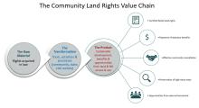
The Community Land Value Chain (CaVaTeCo in Portuguese) is an approach that can improve tenure security and management of community lands and natural resources in the context of large-scale land investments. This note presents this approach.
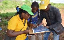
CaVaTeCo Technical Guide 2 - Steps in Delimitation of Family Lands
This guide explains the key steps in the process of land delimitation, in order to help field staff to correctly use the approach.
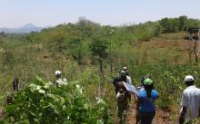
CaVaTeCo Technical Guide 3 - Common Problems in Land Delimitation
By observing teams in the field, combined with analysis of their sketch maps and GPS coordinates, we have identified several frequent mistakes. This guide illustrates frequent problems and mistakes using real examples, and suggests good practices for avoiding or correcting them, and for improving team skills.
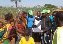
CaVaTeCo Technical Guide 4 - Active Community Participation Improves Efficiency of Family Land Delimitation
A key feature of CaVaTeCo involves participatory delimitation of family land, leading to formal recognition by community associations of the owners’ rights of occupancy.

Community Land Protection Facilitators Guide
This step-by-step guide aims to help community-based organizations and advocates working to help communities protect their customary claims and rights to land and natural resources. It provides tools to:
● Prepare communities for negotiations with investors
● Strengthen community governance of land and natural resources
● Monitor, evaluate and assess the implementation of projects.
This resource is part of the CCSI’s Directory of Community Guidance on Agreements Relating to Agriculture or Forestry Investment.
Improving governance of pastoral lands - Implementing the Voluntary Guidelines on the Responsible Governance of Tenure of Land, Fisheries and Forests in the Context of National Food Security
The technical guide on improving the governance of pastoral lands is designed for several audiences including government and non-government actors. It covers specific challenges of pastoral tenure that are unique to pastoralism and considers how these different facets of pastoralist tenure (issues of the commons; free, prior and informed consent (FPIC); gender etc.) can be combined in a coherent approach to securing pastoral lands.